Friday, May 22, 2015

Archaeology of an Eastern Shore Colonial Plantation


Archaeologists have just come out of the field after a second season of excavation at a colonial site on the eastern shore of Maryland. Although many weeks of laboratory work and analysis are ahead of them, this newly discovered site is already sharing its story!


As part of the Maryland State Highway Administration’s planning process for the replacement of the Dover Bridge in Talbot County, archaeologists searched for the remains of buildings and other historic sites within the project area. While excavating, they found a colonial house and associated structures belonging to a plantation that dates between the late 17th to early 18th century.  This location was likely chosen as a place to settle because of its proximity to a ferry landing on the Choptank River near the town of Easton.


What Did the Archaeologists Find?


After months of excavation archaeologists discovered an amazing assemblage of every day items that included over 13,000 faunal remains (animal bone) and 11,000 domestic, architectural, and personal artifacts.  These discoveries were associated with a variety of structures and features including cellars and pits from six buildings, two privies, a few dozen refuse pits, and over one dozen postholes. Specifically, archaeologists found the remains of bowls, jars, and other ceramics that included: Borderware, Buckley, Staffordshire slipware, tin-glazed earthenware, Westerwald, and North Devon ware.

The preliminary archaeological findings show that the kitchen held cream pots, a butter pot, milk pans, and utensils. Guests and family members drank from mugs, enjoyed cups of tea, and even bottled wine.  The tables were set with a punch bowl, plates, and platters filled with domestic and wild cuts of meat from cows, deer, ducks, and turtles.

Artifact analysis also revealed the occupants spent their leisure time playing the flute, and smoking white clay pipes from England. Additional household objects included straight pints, scissors, and a thimble----evidence of sewing and mending.

One can imagine the disappointment of the person who broke this beautiful Westerwald vessel and the delight of the archaeologist who pieced it back together.


The top of a Bellarmine jug, also called a Bartmann jug (bearded man), was found in a pit. This jug is a round-bellied, narrow necked stoneware vessel made near Cologne, Germany sometime during the 1600s. These jugs were often used to store wines, ale, oil, vinegar, or water.


North Devon gravel tempered chamber pot was only glazed on the inside to ensure the contents were not absorbed into the vessel. Archaeologists were unable to determine whether it was dropped when full or empty. 


Who Lived Here?

Perhaps the biggest question archaeologists wanted to answer was who lived here?  After hours of research they learned the Closiers, Knapps, Andersons, Carrs, Edmundsons, Stuarts, Martins, Richardsons, Walkers, and Hughletts all called this place home at some point. Furthermore, the property stayed in the hands of the daughters of each of the families.


The curious case of the wine bottle seal: Hannah Dickinson's wine bottle seal was found on the site, but she did not live on or near the property.  Through genealogy research archaeologists found Hannah was related to the Walkers, Richardsons, and Edmundsons through her daughter's marriages. 

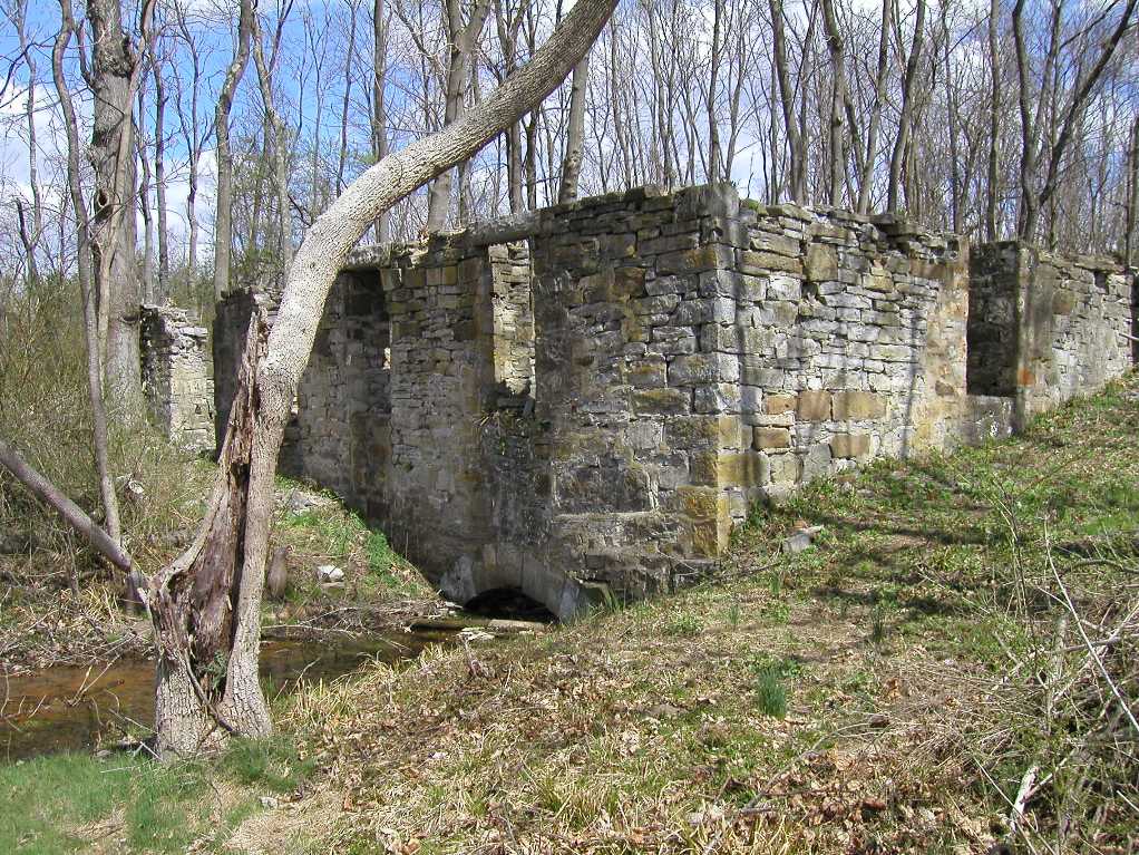
Although the site will be impacted by the new bridge construction, archaeologists had a chance to rescue the artifacts and information from the soil. The opportunity to study this once lost home site provides us a fascinating assemblage of artifacts that will reveal information about how these early Marylanders lived on the eastern shore frontier.

Written by Heather Millis and Julie Schablitsky

Thursday, June 26, 2014

Digging Scott's Plantation, Home of Francis Scott Key's Grandmother, Part I

Anne Arundel County and Maryland State Highway Administration (SHA) archaeologists are busy searching for historic sites along General's Highway. This multi-year project is funded by the federal Transportation Enhancement Program, the County, and SHA. Although the work will include finding and excavating at important sites to learn more about the people who lived here, we also want to better understand the use of the landscape and transportation routes over time. This means railroads and military camps (Rev War and Civil War) are on our list!

Currently, we are studying Scott's Plantation, also known as Belvoir. The property was bought a few years ago by Rockbridge Academy.  They plan to develop their new campus around the estate. Scott's Plantation is best known for being the home of Francis Scott Key's grandmother, Ann Arnold Ross Key. His uncle and aunt, Col. Henry Maynadier and Elizabeth Ross Key Maynadier, also lived on the plantation during the late 18th century through the early 19th century.

View towards west of Scott's Plantation.

While attending St. Johns in Annapolis, Francis Scott Key would visit the plantation. By 1819, he and his uncle Henry Maynadier worked together in an attempt to colonize an area in west Africa (Liberia) through the American Colonization Society.  Although over 12,000 people of African descent were relocated to Africa, the movement failed. 


Francis Scott Key by Dewitt Clinton Peters.
(Photo courtesy of Maryland Historical Society, image #1952.15.10).


The Archaeology (May-June 2014)

Our archaeological work began by attempting to find a very important site, yet a very elusive one---the September 17-18, 1781 Rochambeau Revolutionary War encampment.  Almost 5,000 men camped at Scott's plantation for just several hours before marching to Annapolis and then on to Yorktown, Virginia. The only description of the camp we have is that it was on a hill between the plantation house and the butchery. 


Indeed, the best way to find a military encampment is to metal detect; therefore, we spent two weeks metal detecting across open grass fields west of the plantation house. We also excavated the landscape with shovels, but any evidence of the camp had either been washed away by the active sandy soils or it was never there in the first place. The camp may very well be to the south in an area that use to be part of the original 1,000 acre estate.  Today, it is a development with million dollar homes that surround the 200 year old Belvoir Cemetery; Ann Arnold Key and Henry and Elizabeth Maynadier's infant daughters are buried here. 

Headstone of Mrs. Ann Arnold Key, 1811.

Although we never found the Rochambeau camp, we did find something equally exciting.  When Belvoir went up for sale in 1816, the Maryland Gazette advertised the estate with a "large stone building for servants" (February 29, 1816). During excavation north of the plantation house, we encountered an area full of late 18th-early 19th century debris in the form of animal bone, wine bottle bases, and ceramics.  At this time, it appears that we have a drainage feature where rock, brick, trash was thrown. 

Four, 5 ft. x 5 ft. test units where brick, stone, and historic-artifacts have been collected. Historically, this location was a ditch where refuse was tossed. Numerous wine bottles, 18th and early 19th ceramics (photo below), and animal bone have been recovered here.


But, the question remains...where were these domestic artifacts coming from?  Indeed, this ditch appears a bit too far away from the big house, so there must have been another 200 year old domestic residence close by. 


This week, we uncovered a brick feature and to the north (left in photo) a stone wall.  Could this be the stone servant's (slave) barracks referenced in 1816? We hope to answer this question next month. 

Wednesday, April 16, 2014

A 200 Year Old Mill Site and Civil War Battlefield in Alleghany County

Last week, we traveled to Folck's Mill where our consultant archaeologists are excavating along Interstate 68 in Alleghany County. The site was settled around 1800 and consisted of a 3-story brick grist mill, homes, and old buildings. On August 1, 1864, a small Civil War battle broke out on the site.  Although the area will not be impacted by highway construction, it is important the SHA manages and preserves historic resources in our right of way.  For the past several years, the Civil War Roundtable of Alleghany County has been a steward of the site, keeping the brush down from around the mill ruin. Click here to read the newspaper article!

Folck's MillCivil War Battle of Folck's Mill.jpg
Folck's Mill during the 19th century (left) and today (right).
Courtesy Alleghany County  Historical Society.
Site History
On August 1st, 1864, the Civil War came to Pleasant Mills.  Confederate troops returning from the burning of Chambersburg, Pennsylvania, were ambushed by Union troops, who had placed men and cannon on the high ground west of Pleasant Mills, near the cemetery where Jacob Hoblitzell’s peaceful rest was about to be disturbed.  When Confederate troops reached Pleasant Mills, Union troops opened fire, and the Confederates took shelter among the mill buildings.  Upon retreating, the Confederates placed cannon on high ground to the east of Pleasant Mills, and troops to the north.  Squarely in the center of the battlefield, Folck’s mill and dwelling were struck by shells, and the barn burned.  Casualties were estimated to number between 38 and 50, and the Confederates withdrew the next day.  Folck’s Mill resumed operation after the war, with the grist and sawmill successfully run by tenant millers until Folck sold the complex to the Wolfe brothers in 1894.  Wolfe’s Mill operated only briefly after the sale.


In the mid to late 20th century, the state began to make extensive improvements to the Baltimore-Cumberland Pike, then part of the National Road (US 40), by realigning the road, cutting through the mill property and demolishing the miller’s house.  More changes came to the Evitts Creek area with the construction of the National Freeway (US 48), which eventually became I-68.  Feeder roads were realigned, and a major relocation of US 220 occurred in 2000.  By virtue of these road improvements, SHA owns the original mill site, the Hoblitzell Cemetery, and the center of the Civil War battlefield.

Direct Dimensions scans the mill ruin. Even if it falls down, we will always be able
to virtually visit the site.
 

Next week, archaeologists will finish up their excavation and mapping of the site.  At this point, we have learned that intact layers of soil and artifacts survive around the ruins. Bits of broken dishes, square cut nails, and other artifacts are a strong testament to early life at the mill complex.  We have not found any evidence of the Civil War battle. This is likely a result of the brief nature of the engagement and the disturbance that has taken place over the last 150 years. In addition to mapping and excavating the site, we also hopped across the highway to scan some Civil War grafitti on the attic walls at Puccini's Restaurant.  Allegedly, this building, originally a home, functioned as a hospital following the Battle of Folck's Mill.

Civil War grafitti on the attic walls at Puccinis.

Archaeologists excavate next to the ruins of an outbuilding. They have recovered over
200 nails from this unit alone as well as a old bottle base and stoneware sherds.