Last week, we traveled to Folck's Mill where our consultant archaeologists are excavating along Interstate 68 in Alleghany County. The site was settled around 1800 and consisted of a 3-story brick grist mill, homes, and old buildings. On August 1, 1864, a small Civil War battle broke out on the site. Although the area will not be impacted by highway construction, it is important the SHA manages and preserves historic resources in our right of way. For the past several years, the Civil War Roundtable of Alleghany County has been a steward of the site, keeping the brush down from around the mill ruin.
Click here to read the newspaper article!
 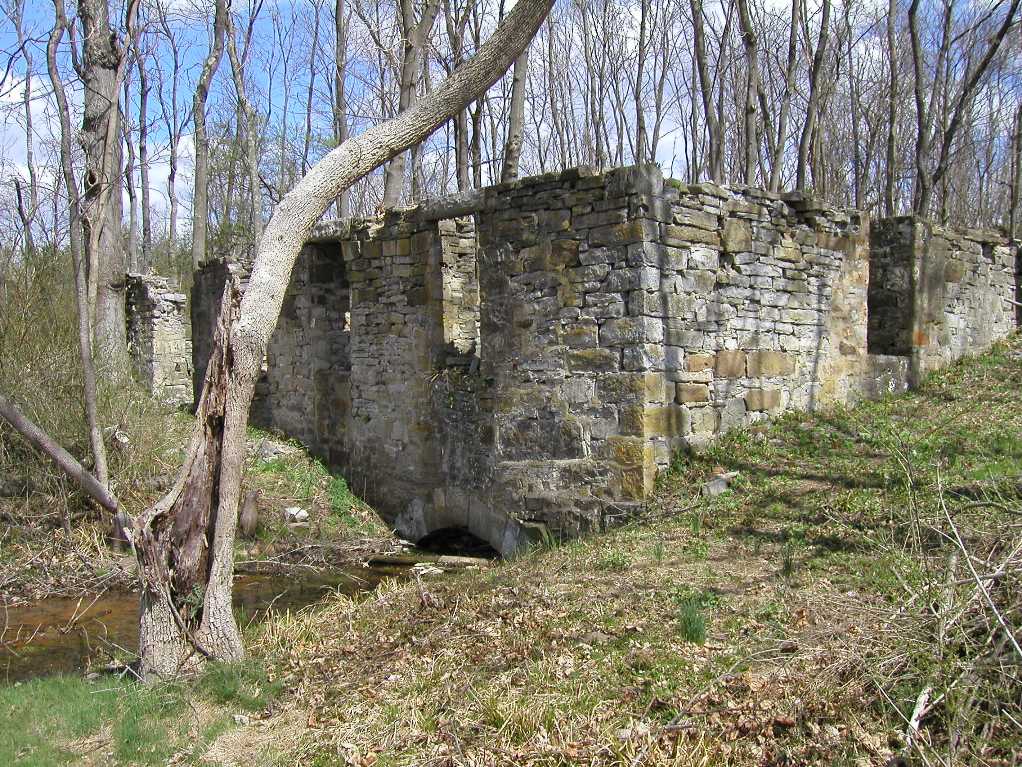 |
Folck's Mill during the 19th century (left) and today (right).
Courtesy Alleghany County Historical Society. |
Site History
On August 1
st, 1864,
the Civil War came
to Pleasant Mills. Confederate
troops returning from
the burning of
Chambersburg, Pennsylvania, were ambushed by Union troops, who had placed
men and cannon on the high ground west of Pleasant Mills, near the cemetery
where Jacob Hoblitzell’s peaceful rest was about to be disturbed. When Confederate troops reached Pleasant
Mills, Union troops opened fire, and the Confederates took shelter among the
mill buildings. Upon retreating, the
Confederates placed cannon on high ground to the east of Pleasant Mills, and
troops to the north. Squarely in the
center of the battlefield, Folck’s mill and dwelling were struck by shells, and
the barn burned. Casualties were
estimated to number between 38 and 50, and the Confederates withdrew the next
day. Folck’s Mill resumed operation
after the war, with the grist and sawmill successfully run by tenant millers
until Folck sold the complex to the Wolfe brothers in 1894. Wolfe’s Mill operated only briefly after the
sale.
In the mid to late 20
th
century, the state began to make extensive improvements to the
Baltimore-Cumberland Pike, then part of the National Road (US 40), by
realigning the road, cutting through the mill property and demolishing the
miller’s house. More changes came to the
Evitts Creek area with the construction of the National Freeway (US 48), which
eventually became I-68. Feeder roads
were realigned, and a major relocation of US 220 occurred in 2000. By virtue of these road improvements, SHA
owns the original mill site, the Hoblitzell Cemetery, and the center of the
Civil War battlefield.
 |
Direct Dimensions scans the mill ruin. Even if it falls down, we will always be able
to virtually visit the site.
|
Next week, archaeologists will finish up their excavation and mapping of the site. At this point, we have learned that intact layers of soil and artifacts survive around the ruins. Bits of broken dishes, square cut nails, and other artifacts are a strong testament to early life at the mill complex. We have not found any evidence of the Civil War battle. This is likely a result of the brief nature of the engagement and the disturbance that has taken place over the last 150 years. In addition to mapping and excavating the site, we also hopped across the highway to scan some Civil War grafitti on the attic walls at
Puccini's Restaurant. Allegedly, this building, originally a home, functioned as a hospital following the Battle of Folck's Mill.
 |
| Civil War grafitti on the attic walls at Puccinis. |
 |
Archaeologists excavate next to the ruins of an outbuilding. They have recovered over
200 nails from this unit alone as well as a old bottle base and stoneware sherds. |
No comments:
Post a Comment